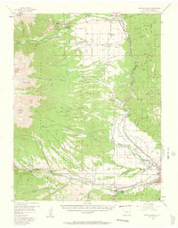
1956 Map of Poncha Springs
USGS Topo · Published 1962About this map
The Arkansas River valley serves as a bustling corridor for settlement and transit in this mid-century survey of Chaffee County. Communities like Poncha Springs and Salida anchor the southern landscape, while Nathrop and Centerville mark the northward route of the Denver and Rio Grande Western Railroad. The terrain is defined by dramatic shifts in elevation, transitioning from the agricultural flats of Missouri Park to the high peaks of the San Isabel National Forest, including Mt Princeton and Shavano Peak. Local infrastructure reflects a diverse economy, from the Hydroelectric Plant and Salida Airport to the Chalk Cliff Fish Hatchery. For genealogists, the map preserves the locations of early rural institutions like the Centerville School, the Nathrop School, and Fairview Cemetery, alongside industrial remnants such as the Lucky Mine and the irrigation network of the Bowen Ditch.
Find a feature on this map
82 named features on this map. Tap any name to fly to it.
Don’t see what you’re looking for? This feature index may not catch every label — zoom into the map to look around manually.
Map Details
Editions of this 1956 Poncha Springs Map
6 editions found

Other maps of this area

1940 · Garfield
USGS Topo · 1:62,500

1945 · Garfield
USGS Topo · 1:62,500

1954 · Pueblo
USGS Topo · 1:250,000

1955 · Buena Vista
USGS Topo · 1:62,500

1955 · Mount Harvard
USGS Topo · 1:62,500

1956 · Cameron Mountain
USGS Topo · 1:62,500

1956 · Poncha Springs
USGS Topo · 1:62,500

1956 · Montrose
USGS Topo · 1:250,000

1957 · Pueblo
USGS Topo · 1:250,000

1958 · Pueblo
USGS Topo · 1:250,000