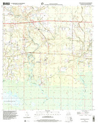
1998 Map of Ponchatoula NE
USGS Topo · Published 2001About this map
The Tangipahoa River and Bedico Creek define this section of Tangipahoa Parish, where the alluvial landscape is marked by numerous bayous and small family cemeteries. Settled life in the late 20th century centered around rural church gatherings at places like Wesley Chapel and Good Hope Ch, while the Champ Cooper Sch served the local community. The presence of Lees Landing and Traino Landing reflects a long-standing relationship with the water, facilitating movement through the swampy lowlands.
Find a feature on this map
39 named features on this map. Tap any name to fly to it.
Don’t see what you’re looking for? This feature index may not catch every label — zoom into the map to look around manually.
Map Details
Editions of this 1998 Ponchatoula NE Map
This is the sole edition of this map. No revisions or reprints were ever made.
Other maps of this area

1935 · Covington
USGS Topo · 1:62,500

1935 · Ponchatoula
USGS Topo · 1:62,500

1939 · Ponchatoula
USGS Topo · 1:62,500

1939 · Covington
USGS Topo · 1:62,500

1940 · Tickfaw
USGS Topo · 1:31,680

1942 · Onville
USGS Topo · 1:31,680

1942 · Robert
USGS Topo · 1:31,680

1950 · Covington
USGS Topo · 1:62,500

1951 · Ponchatoula
USGS Topo · 1:62,500

1954 · Folsom
USGS Topo · 1:62,500