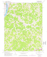
1960 Map of Pond Creek
USGS Topo · Published 1976About this map
Belleville Lock and Dam and the adjacent Baltimore and Ohio railroad corridor anchor this West Virginia and Ohio borderlands landscape along the Ohio River. The 1960 field check captures the intricate topography of Dutch Ridge and Milhoan Ridge, where small communities like Belleville and Reedsville developed alongside fertile river flats at Olive Bottom. The interior reveals a dense network of family history markers, including the Jordan Cem, Boso Cem, and Shafer Cem, which are scattered among the deep drainages of Lee Creek and Pond Creek.
Find a feature on this map
95 named features on this map. Tap any name to fly to it.
Don’t see what you’re looking for? This feature index may not catch every label — zoom into the map to look around manually.
Map Details
Editions of this 1960 Pond Creek Map
3 editions found
Other maps of this area

1906 · Belleville
USGS Topo · 1:62,500

1907 · Keno
USGS Topo · 1:62,500

1907 · Ripley
USGS Topo · 1:62,500

1908 · Ravenswood
USGS Topo · 1:62,500

1924 · Belleville
USGS Topo · 1:62,500

1926 · Ravenswood
USGS Topo · 1:62,500

1926 · Belleville
USGS Topo · 1:62,500

1926 · Ripley
USGS Topo · 1:62,500

1928 · Ravenswood
USGS Topo · 1:62,500

1928 · Ripley
USGS Topo · 1:62,500