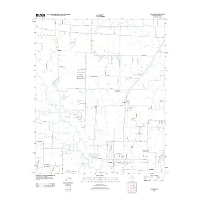
2013 Map of Ponder
USGS Topo · Published 2013About this map
The town of Ponder serves as a central hub in this Denton County landscape, characterized by a transition from traditional agricultural patterns to modern residential developments and specialized infrastructure. The map reveals an unusual density of private aviation facilities, including Palmer Field Airport, Deussen Field Airport, and Dew Drop Airport, suggesting a local economy or culture deeply integrated with small-aircraft travel. Evidence of the area's rural foundations remains visible at the Akain Cem and Stony Cem, as well as established settlements like Stony and the colorfully named Drop. Waterways such as Denton Cr and Hog Br meander through the southern reaches, where the City of Denton Water Treatment Facility marks significant civic investment. The southern edge of the quadrangle shows the expanding footprints of Dish and Northlake, illustrating the northward growth of the Dallas-Fort Worth metroplex during this era.
Find a feature on this map
77 named features on this map. Tap any name to fly to it.
Don’t see what you’re looking for? This feature index may not catch every label — zoom into the map to look around manually.
Map Details
Editions of this 2013 Ponder Map
This is the sole edition of this map. No revisions or reprints were ever made.
Other maps of this area

1954 · Sherman
USGS Topo · 1:250,000

1958 · Sherman
USGS Topo · 1:250,000

1959 · Ponder
USGS Topo · 1:24,000
1960 · Justin
USGS Topo · 1:24,000

1960 · Sanger
USGS Topo · 1:24,000

1960 · Bluett
USGS Topo · 1:24,000
1960 · Argyle
USGS Topo · 1:24,000

1960 · Rhome
USGS Topo · 1:24,000
1960 · Denton West
USGS Topo · 1:24,000

1961 · Slidell
USGS Topo · 1:24,000