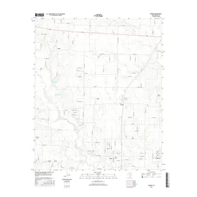
2016 Map of Ponder
USGS Topo · Published 2016About this map
Ponder and its surrounding prairie landscape in Denton County are defined by a network of farm-to-market roads and several private airstrips. The terrain is characterized by the winding path of Denton Creek, which flows through the Eagle Valley area and is fed by several seasonal tributaries including Wolf Br and Hog Br. Local genealogy is anchored by established sites such as Stony Cem and Akain Cem, alongside the small settlements of Stony, Drop, and the uniquely named town of Dish. The region's aviation interests are prominent, with multiple small fields like Deussen Field, Roma Airport, and Sagebrush Airport scattered across the township lines. Irrigation and local water management are visible through the C Hobson Dunn Lake Number 1 and C Hobson Dunn Lake Number 2, which support the agricultural tracts that remain between the growing residential footprints of Northlake.
Find a feature on this map
104 named features on this map. Tap any name to fly to it.
Don’t see what you’re looking for? This feature index may not catch every label — zoom into the map to look around manually.
Map Details
Editions of this 2016 Ponder Map
This is the sole edition of this map. No revisions or reprints were ever made.
Other maps of this area

1954 · Sherman
USGS Topo · 1:250,000

1958 · Sherman
USGS Topo · 1:250,000

1959 · Ponder
USGS Topo · 1:24,000
1960 · Justin
USGS Topo · 1:24,000

1960 · Sanger
USGS Topo · 1:24,000

1960 · Bluett
USGS Topo · 1:24,000
1960 · Argyle
USGS Topo · 1:24,000

1960 · Rhome
USGS Topo · 1:24,000
1960 · Denton West
USGS Topo · 1:24,000

1961 · Slidell
USGS Topo · 1:24,000