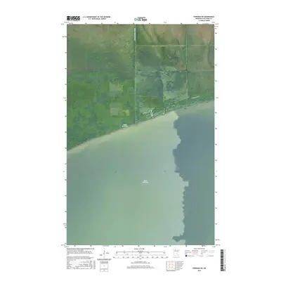
2016 Map of Ponemah NE
USGS Topo · Published 2016About this map
Upper Red Lake dominates the southern half of this landscape, its expansive waters meeting a northern shoreline characterized by extensive wetlands. The geography is defined by the Public Land Survey System divisions of t155n r33w, t155n r32w, and t154n r33w, which segment the dense marshy terrain north of the lake. Access to this wilderness area is extremely limited, with Blanchard Trl Ne serving as the primary corridor skirting the edge of the wetlands. This map provides a clear view of the undeveloped shoreline and the vast, uninhabited bog systems that comprise the northern reaches of Beltrami County, illustrating the preservation of this remote aquatic environment.
Find a feature on this map
5 named features on this map. Tap any name to fly to it.
Don’t see what you’re looking for? This feature index may not catch every label — zoom into the map to look around manually.
Map Details
Editions of this 2016 Ponemah NE Map
This is the sole edition of this map. No revisions or reprints were ever made.
Other maps of this area

1919 · G
USGS Topo · 1:62,500

1919 · Fox
USGS Topo · 1:62,500

1919 · Ponemah
USGS Topo · 1:62,500

1919 · Knutson
USGS Topo · 1:62,500

1943 · Ponemah
USGS Topo · 1:62,500

1954 · Roseau
USGS Topo · 1:250,000

1957 · Roseau
USGS Topo · 1:250,000

1958 · Roseau
USGS Topo · 1:250,000
1973 · Waskish NW
USGS Topo · 1:24,000
1973 · Chase Brook SW
USGS Topo · 1:24,000