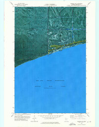
1974 Map of Ponemah NE
USGS Topo · Published 1976About this map
Upper Red Lake dominates the southern half of this orthophotomap, its shoreline forming a distinct boundary against the dense vegetation of the north. The landscape is primarily composed of the Red Lake Indian Reservation and the Red Lake State Wildlife Management Area, showing a terrain largely defined by forest and wetlands. Human intervention is sparse, represented by a few key corridors such as the Waskish Thorhult Road and a Winter Trail that cuts through the wilderness. This survey provides a precise visual record of the shoreline and internal drainage patterns in northern Minnesota during the mid-1970s. The aerial photography used to produce this map reveals the intricate texture of the peatlands and forest canopy within the reservation boundaries.
Find a feature on this map
6 named features on this map. Tap any name to fly to it.
Don’t see what you’re looking for? This feature index may not catch every label — zoom into the map to look around manually.
Map Details
Editions of this 1974 Ponemah NE Map
This is the sole edition of this map. No revisions or reprints were ever made.
Other maps of this area

1919 · G
USGS Topo · 1:62,500

1919 · Fox
USGS Topo · 1:62,500

1919 · Ponemah
USGS Topo · 1:62,500

1919 · Knutson
USGS Topo · 1:62,500

1943 · Ponemah
USGS Topo · 1:62,500

1954 · Roseau
USGS Topo · 1:250,000

1957 · Roseau
USGS Topo · 1:250,000

1958 · Roseau
USGS Topo · 1:250,000
1973 · Waskish NW
USGS Topo · 1:24,000
1973 · Chase Brook SW
USGS Topo · 1:24,000