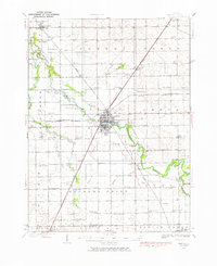
1935 Map of Pontiac
USGS Topo · Published 1976About this map
The State Reformatory stands as a prominent landmark on the southern edge of Pontiac, anchoring this 1935 survey of Livingston County. The landscape is defined by the winding course of the Vermilion River, which passes through the heart of the county seat and continues north toward Cornell. This era captures a dense network of rural infrastructure, with nearly every section of land supporting a localized schoolhouse such as Esmen Center Sch, Wolf Creek Sch, or Bashore Sch.
Find a feature on this map
87 named features on this map. Tap any name to fly to it.
Don’t see what you’re looking for? This feature index may not catch every label — zoom into the map to look around manually.
Map Details
Editions of this 1935 Pontiac Map
2 editions found
Other maps of this area

1925 · Streator
USGS Topo · 1:62,500

1926 · Normal
USGS Topo · 1:62,500

1927 · Streator
USGS Topo · 1:62,500

1930 · Normal
USGS Topo · 1:62,500

1935 · Pontiac
USGS Topo · 1:62,500

1939 · Pontiac
USGS Topo · 1:62,500

1947 · Sibley
USGS Topo · 1:62,500

1947 · Cullom
USGS Topo · 1:62,500

1948 · Dwight
USGS Topo · 1:62,500

1949 · Cullom
USGS Topo · 1:62,500