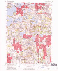
1968 Map of Pontiac South
USGS Topo · Published 1971About this map
Glacial lake landscapes define the residential and recreational character of Oakland County in this 1968 study. Dense suburban development surrounds Cass Lake, Pine Lake, and Orchard Lake, where the prominent Apple Island sits centrally. The Grand Trunk Western railroad cuts across the northern landscape near Keego Harbor and Sylvan Lake, providing a corridor for the growth of these lakeside communities. The map highlights the area's transition into an educational and leisure hub, with institutions such as St Marys College and Cranbrook Sch established alongside expansive grounds like the Oakland Hills Country Club. Smaller settlements such as Franklin and Bingham Farms show a pattern of estate-style planning, while the Clinton River and Hadsells Pond provide the hydrologic backdrop for the rolling terrain north of Southfield.
Find a feature on this map
128 named features on this map. Tap any name to fly to it.
Don’t see what you’re looking for? This feature index may not catch every label — zoom into the map to look around manually.
Map Details
Editions of this 1968 Pontiac South Map
3 editions found
Other maps of this area

1905 · Wayne
USGS Topo · 1:62,500

1905 · Detroit
USGS Topo · 1:62,500

1907 · Pontiac
USGS Topo · 1:62,500

1908 · Rochester
USGS Topo · 1:62,500

1912 · Wayne
USGS Topo · 1:62,500

1918 · Detroit
USGS Topo · 1:62,500

1924 · Detroit
USGS Topo · 1:62,500

1934 · Detroit
USGS Topo · 1:62,500

1936 · Birmingham
USGS Topo · 1:31,680

1936 · Clarkston
USGS Topo · 1:31,680