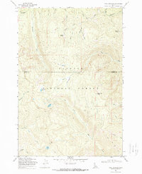
1969 Map of Pony Meadows
USGS Topo · Published 1972About this map
Keystone Meadows and Little Pony Meadows occupy a high-altitude landscape within the Payette National Forest during this late 1960s survey. The area is defined by its complex drainage network, where headwaters such as Pony Creek and Bear Creek carve through steep terrain. Human activity is largely confined to a system of primitive routes, including a Jeep Trail and several Pack Trails, which provided access for forestry and mining. Evidence of mineral exploration appears in the north, where a Mine is located near the head of Arise Gulch. The map records significant high-elevation points like Warren Summit and Steamboat Summit, alongside numerous alpine water bodies such as Bear Lake, Blue Lake, and Steamboat Lake. This cartographic record documents the remote boundary between Idaho and Valley Counties before modern development altered these backcountry corridors.
Find a feature on this map
34 named features on this map. Tap any name to fly to it.
Don’t see what you’re looking for? This feature index may not catch every label — zoom into the map to look around manually.
Map Details
Editions of this 1969 Pony Meadows Map
2 editions found
Other maps of this area

1956 · Burgdorf
USGS Topo · 1:62,500

1956 · Warren
USGS Topo · 1:62,500

1956 · Elk City
USGS Topo · 1:250,000

1960 · Elk City
USGS Topo · 1:250,000

1969 · Loon Lake
USGS Topo · 1:24,000

1969 · Pony Meadows
USGS Topo · 1:24,000

1969 · Enos Lake
USGS Topo · 1:24,000

1969 · Parks Peak
USGS Topo · 1:24,000

1969 · Williams Peak
USGS Topo · 1:24,000

1969 · Pilot Peak
USGS Topo · 1:24,000