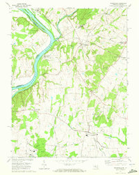
1970 Map of Poolesville
USGS Topo · Published 1972About this map
The Potomac River corridor serves as the western boundary of this 1970 landscape, where the Chesapeake and Ohio Canal and its historic Towpath parallel the water's edge. A notable engineering landmark, the Monocacy Aqueduct, spans the Monocacy River near its mouth, illustrating the infrastructure of nineteenth-century transport alongside the modern Baltimore and Ohio Railroad. Further inland, the map captures the rural character of northern Montgomery County through several crossroads communities, including Poolesville, Beallsville, and Barnesville.
Find a feature on this map
68 named features on this map. Tap any name to fly to it.
Don’t see what you’re looking for? This feature index may not catch every label — zoom into the map to look around manually.
Map Details
Editions of this 1970 Poolesville Map
2 editions found
Other maps of this area

1884 · Harpers Ferry
USGS Topo · 1:125,000

1891 · Harpers Ferry
USGS Topo · 1:125,000

1893 · Frederick
USGS Topo · 1:125,000

1893 · Harpers Ferry
USGS Topo · 1:125,000

1894 · Frederick
USGS Topo · 1:125,000

1908 · Middletown
USGS Topo · 1:48,000

1908 · Seneca
USGS Topo · 1:62,500

1908 · Ijamsville
USGS Topo · 1:62,500

1909 · Ijamsville
USGS Topo · 1:62,500

1910 · Antietam
USGS Topo · 1:62,500