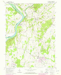
1970 Map of Poolesville
USGS Topo · Published 1978About this map
The Potomac River and the Monocacy River converge in this 1970s landscape, where the historic C & O Canal National Historic Park and its Towpath follow the river's bend. This survey documents a rural corridor of Montgomery County preserved through significant institutional and park land, including the Dickerson Regional Park and the sprawling National Institutes of Health Animal Farm near Elmer. Local infrastructure of the era is clearly visible, from the powerplant and its conveyor near the river to the Baltimore and Ohio Railroad connecting settlements like Dickerson, Barnesville, and Sellman. Small rural communities and historic crossroads are well-defined, featuring landmarks such as the Monocacy Aqueduct, Mt Zion Ch, and Elijah Ch. The map also captures several islands within the Potomac, including Mason Island and Cox Island, alongside the transition from agricultural fields to the burgeoning residential footprints in Poolesville.
Find a feature on this map
74 named features on this map. Tap any name to fly to it.
Don’t see what you’re looking for? This feature index may not catch every label — zoom into the map to look around manually.
Map Details
Editions of this 1970 Poolesville Map
2 editions found
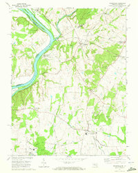
Other maps of this area

1884 · Harpers Ferry
USGS Topo · 1:125,000

1891 · Harpers Ferry
USGS Topo · 1:125,000

1893 · Frederick
USGS Topo · 1:125,000

1893 · Harpers Ferry
USGS Topo · 1:125,000

1894 · Frederick
USGS Topo · 1:125,000

1908 · Middletown
USGS Topo · 1:48,000

1908 · Seneca
USGS Topo · 1:62,500

1908 · Ijamsville
USGS Topo · 1:62,500

1909 · Ijamsville
USGS Topo · 1:62,500

1910 · Antietam
USGS Topo · 1:62,500