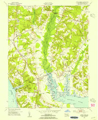
1953 Map of Popes Creek
USGS Topo · Published 1954About this map
Zekiah Swamp Run dominates the central topography of this 1953 Maryland study, creating a broad wetland corridor that separates the western highlands from the settlements of the east. The Pennsylvania railroad line runs parallel to the Potomac shoreline, serving critical transit points like Bel Alton (Cox Sta) and Faulkner (Lothair Sta). These dual-named stations reflect the evolution of local commerce where rail stops often carried different names than the established post offices.
Find a feature on this map
69 named features on this map. Tap any name to fly to it.
Don’t see what you’re looking for? This feature index may not catch every label — zoom into the map to look around manually.
Map Details
Editions of this 1953 Popes Creek Map
5 editions found

Other maps of this area

1889 · Fredericksburg
USGS Topo · 1:125,000

1890 · Mt. Vernon
USGS Topo · 1:125,000

1891 · Mt. Vernon
USGS Topo · 1:125,000

1892 · Fredericksburg
USGS Topo · 1:125,000

1892 · Brandywine
USGS Topo · 1:62,500

1894 · Wicomico
USGS Topo · 1:62,500

1894 · Fredericksburg
USGS Topo · 1:125,000

1894 · Mt. Vernon
USGS Topo · 1:125,000

1895 · Wicomico
USGS Topo · 1:62,500

1895 · Brandywine
USGS Topo · 1:62,500