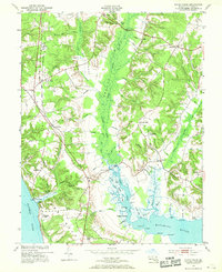
1953 Map of Popes Creek
USGS Topo · Published 1969About this map
Zekiah Swamp dominates the central corridor of this Maryland landscape, where numerous tributaries like Rice Run and Bowling Creek converge into the Allens Fresh Run estuary. The mid-century transport network is anchored by the Pennsylvania railroad line, which passes through Bel Alton (Cox Sta) and Faulkner before terminating near the Potomac shore. This rail connection highlights the historical importance of Popes Creek, a terminal point situated along the river bluffs near Ravens Crest. Along the southern shoreline, the Wicomico River meets the Potomac, framing a peninsula of named terrain including Ben Neck and Ellenboro Hill. Local history and community life are marked by landmarks like St Marys Ch, the Fairgrounds near Newtown, and small rural clusters such as Newport and Allens Fresh, providing a detailed look at the agricultural and river-based economy of Charles County.
Find a feature on this map
81 named features on this map. Tap any name to fly to it.
Don’t see what you’re looking for? This feature index may not catch every label — zoom into the map to look around manually.
Map Details
Editions of this 1953 Popes Creek Map
5 editions found

Other maps of this area

1889 · Fredericksburg
USGS Topo · 1:125,000

1890 · Mt. Vernon
USGS Topo · 1:125,000

1891 · Mt. Vernon
USGS Topo · 1:125,000

1892 · Fredericksburg
USGS Topo · 1:125,000

1892 · Brandywine
USGS Topo · 1:62,500

1894 · Wicomico
USGS Topo · 1:62,500

1894 · Fredericksburg
USGS Topo · 1:125,000

1894 · Mt. Vernon
USGS Topo · 1:125,000

1895 · Wicomico
USGS Topo · 1:62,500

1895 · Brandywine
USGS Topo · 1:62,500