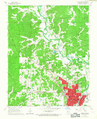
1966 Map of Poplar Bluff
USGS Topo · Published 1967About this map
Poplar Bluff serves as the focal point of this mid-1960s survey, showing the city's concentrated development alongside the Black River. The urban core is detailed with civic landmarks including the Courthouse, Armory, and a VA Hospital, while the surrounding landscape transitions into the heavily wooded sections of the Clark National Forest. For those researching family history, the map provides precise locations for numerous rural burial grounds such as Three Springs Cemetery and Nunley Cemetery, along with several vanished schoolhouses like Agee School and Oak Grove School.
Find a feature on this map
70 named features on this map. Tap any name to fly to it.
Don’t see what you’re looking for? This feature index may not catch every label — zoom into the map to look around manually.
Map Details
Editions of this 1966 Poplar Bluff Map
3 editions found
Other maps of this area

1934 · Williamsville
USGS Topo · 1:48,000

1935 · Poplar Bluff
USGS Topo · 1:62,500

1935 · Acorn
USGS Topo · 1:62,500

1935 · Harviell
USGS Topo · 1:62,500

1939 · Poplar Bluff
USGS Topo · 1:62,500

1940 · Williamsville
USGS Topo · 1:62,500

1940 · Naylor
USGS Topo · 1:62,500

1944 · Naylor
USGS Topo · 1:62,500

1949 · Poplar Bluff
USGS Topo · 1:62,500

1957 · Poplar Bluff
USGS Topo · 1:250,000