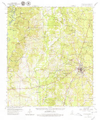
1959 Map of Poplarville
USGS Topo · Published 1979About this map
Poplarville serves as the focal point of this Mississippi landscape, shown at a time of significant transition as oil and gas exploration expanded alongside the established timber and rail industries. The town's layout is meticulously detailed, including the campus of Pearl River Jr College and several local churches like Sunny Hill Ch and East Pearl Ch. To the north, the village of Orvisburg and its namesake Orvisburg Lake mark a former center of the lumber trade, while the Southern Railway provides the primary industrial artery through the region.
Find a feature on this map
60 named features on this map. Tap any name to fly to it.
Don’t see what you’re looking for? This feature index may not catch every label — zoom into the map to look around manually.
Map Details
Editions of this 1959 Poplarville Map
3 editions found

Other maps of this area

1942 · Pools Bluff
USGS Topo · 1:31,680

1949 · Bogalusa East
USGS Topo · 1:31,680

1949 · Angie
USGS Topo · 1:31,680

1953 · Hattiesburg
USGS Topo · 1:250,000

1953 · Mobile
USGS Topo · 1:250,000

1955 · Savannah
USGS Topo · 1:62,500

1957 · Mobile
USGS Topo · 1:250,000

1958 · Hattiesburg
USGS Topo · 1:250,000

1958 · Carnes
USGS Topo · 1:62,500

1958 · Picayune
USGS Topo · 1:62,500