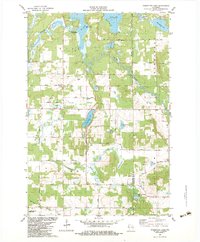
1982 Map of Poquettes Lake
USGS Topo · Published 1983About this map
The Yellow River winds through this Northwest Wisconsin landscape, where the St Croix Indian Reservation occupies a significant tract along the shores of Rice Lake. This 1982 map illustrates a rural interior defined by its glacial hydrology, featuring a dense network of lakes such as Lipsett Lake, Poquettes Lake, and Meads Lake. The settlement pattern is sparse, centered around local institutions like the Green Grove Alliance Ch and the nearby Greendale Cem in the Greendale area.
Find a feature on this map
43 named features on this map. Tap any name to fly to it.
Don’t see what you’re looking for? This feature index may not catch every label — zoom into the map to look around manually.
Map Details
Editions of this 1982 Poquettes Lake Map
This is the sole edition of this map. No revisions or reprints were ever made.
Other maps of this area

1948 · Spooner
USGS Topo · 1:48,000

1949 · Hertel
USGS Topo · 1:48,000

1949 · Spooner
USGS Topo · 1:48,000

1951 · Cumberland
USGS Topo · 1:48,000

1951 · Shell Lake
USGS Topo · 1:48,000

1953 · Rice Lake
USGS Topo · 1:250,000

1953 · Stillwater
USGS Topo · 1:250,000

1955 · Hertel
USGS Topo · 1:62,500

1955 · Stillwater
USGS Topo · 1:250,000

1956 · Cumberland
USGS Topo · 1:62,500