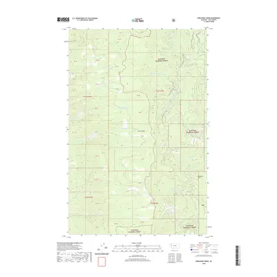
2020 Map of Porcupine Creek
USGS Topo · Published 2020About this map
The high alpine crests of the Mission Range dominate this 2020 topographic study of Lake County. Set within the boundaries of the Flathead National Forest, the landscape is defined by a dense network of drainage systems flowing outward from the mountain peaks. Numerous water bodies including Talking Water Creek, Blue Bay Creek, and Boulder Creek carve through the steep terrain, illustrating the hydrologic character of this protected wilderness. At the northern edge, Natl Forest Road 9719 RD and the colorfully named Lake-To-Sky Rd provide access into the forest. For researchers and backcountry enthusiasts, the map meticulously tracks the seasonal access routes, such as the Crane Mtn Snowmobile Spur B, which winds through the elevations near Woodward Point.
Find a feature on this map
22 named features on this map. Tap any name to fly to it.
Don’t see what you’re looking for? This feature index may not catch every label — zoom into the map to look around manually.
Map Details
Editions of this 2020 Porcupine Creek Map
This is the sole edition of this map. No revisions or reprints were ever made.
Other maps of this area

1920 · Flathead Lake
USGS Topo · 1:125,000

1955 · Choteau
USGS Topo · 1:250,000

1956 · Wallace
USGS Topo · 1:250,000

1957 · Choteau
USGS Topo · 1:250,000

1958 · Choteau
USGS Topo · 1:250,000

1960 · Wallace
USGS Topo · 1:250,000

1962 · Choteau
USGS Topo · 1:250,000

1964 · Bull Island
USGS Topo · 1:24,000

1964 · East Bay
USGS Topo · 1:24,000
1964 · Woods Bay
USGS Topo · 1:24,000