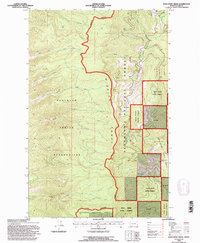
1994 Map of Porcupine Creek
USGS Topo · Published 1996About this map
The Mission Range forms a dramatic central divider in this western Montana landscape, marking the significant Flathead Indian Reservation Boundary. To the west, the slopes are part of the Flathead Indian Reservation, characterized by high-elevation drainages such as Blue Bay Creek and Teepee Creek that flow toward the west. This 1994 revision shows the intricate jurisdictional boundaries of the mid-1990s, where federal reservation lands meet the Flathead National Forest and the Swan River State Forest. To the east of the divide, the terrain drops toward the valley of the Swan River, fed by numerous tributaries including Porcupine Creek and Whitetail Creek. A notable landmark in the southeastern corner is Woodward Point, overlooking the junction of mountain streams and forest management zones.
Find a feature on this map
19 named features on this map. Tap any name to fly to it.
Don’t see what you’re looking for? This feature index may not catch every label — zoom into the map to look around manually.
Map Details
Editions of this 1994 Porcupine Creek Map
This is the sole edition of this map. No revisions or reprints were ever made.
Other maps of this area

1920 · Flathead Lake
USGS Topo · 1:125,000

1955 · Choteau
USGS Topo · 1:250,000

1956 · Wallace
USGS Topo · 1:250,000

1957 · Choteau
USGS Topo · 1:250,000

1958 · Choteau
USGS Topo · 1:250,000

1960 · Wallace
USGS Topo · 1:250,000

1962 · Choteau
USGS Topo · 1:250,000

1964 · Bull Island
USGS Topo · 1:24,000

1964 · East Bay
USGS Topo · 1:24,000
1964 · Woods Bay
USGS Topo · 1:24,000