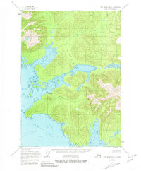
1951 Map of Port Alexander C-1
USGS Topo · Published 1981About this map
Kuiu Island's intricate shoreline and internal waterways define this 1951 study of the Tongass National Forest. The map documents a specialized maritime economy on the Bay of Pillars, anchored by the Pillar Bay Cannery and a nearby Seaplane Base, which served as vital links for logistics and industry in this roadless region. The landscape is dominated by complex hydrographic features, from the tidal reaches of Rowan Bay to the inland waters of Kutlaku Lake and Alecks Lake. These freshwater systems, including Kadake Creek and Kwatahein Creek, suggest the importance of seasonal salmon runs to the area's development. Small maritime refuges like Piledriver Cove and Happy Cove are noted along the southern coast near Tebenkof Bay, providing essential data for local navigation and historical shoreline reconstruction.
Find a feature on this map
18 named features on this map. Tap any name to fly to it.
Don’t see what you’re looking for? This feature index may not catch every label — zoom into the map to look around manually.
Map Details
Editions of this 1951 Port Alexander C-1 Map
3 editions found

Other maps of this area

1948 · Port Alexander C-1
USGS Topo · 1:63,360

1948 · Petersburg B-6
USGS Topo · 1:63,360

1948 · Port Alexander B-1
USGS Topo · 1:63,360

1948 · Petersburg D-6
USGS Topo · 1:63,360

1948 · Port Alexander D-1
USGS Topo · 1:63,360

1948 · Petersburg C-6
USGS Topo · 1:63,360

1948 · Port Alexander B-2
USGS Topo · 1:63,360

1951 · Port Alexander C-2
USGS Topo · 1:63,360

1951 · Port Alexander
USGS Topo · 1:250,000

1951 · Port Alexander D-2
USGS Topo · 1:63,360