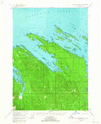
1948 Map of Port Alexander D-1
USGS Topo · Published 1963About this map
Kuiu Island dominates this 1948 topographic study, showcasing the intricate coastal geography of Southeast Alaska within the Tongass National Forest. The landscape is defined by deep maritime indentations, most notably Saginaw Bay and Security Bay, which carved into the island's timbered interior. A lone Cannery situated on the eastern shore of Saginaw Bay reflects the region's mid-century industrial reliance on the sea, while scattered Cabins and a Cabin indicate isolated outposts for fishing or trapping.
Find a feature on this map
23 named features on this map. Tap any name to fly to it.
Don’t see what you’re looking for? This feature index may not catch every label — zoom into the map to look around manually.
Map Details
Editions of this 1948 Port Alexander D-1 Map
4 editions found
Other maps of this area

1948 · Sitka A-2
USGS Topo · 1:63,360

1948 · Port Alexander C-1
USGS Topo · 1:63,360

1948 · Sumdum A-6
USGS Topo · 1:63,360

1948 · Petersburg D-6
USGS Topo · 1:63,360

1948 · Port Alexander D-1
USGS Topo · 1:63,360

1948 · Petersburg C-6
USGS Topo · 1:63,360

1948 · Sitka A-1
USGS Topo · 1:63,360

1951 · Sitka
USGS Topo · 1:250,000

1951 · Port Alexander C-2
USGS Topo · 1:63,360

1951 · Port Alexander
USGS Topo · 1:250,000