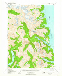
1951 Map of Port Alexander D-3
USGS Topo · Published 1962About this map
Baranof Island is documented here through a 1951 field annotation, revealing a wilderness landscape shaped by steep glacially-carved topography and deep saltwater inlets. Along the eastern shore, Red Bluff Bay serves as a focal point for former industrial activity, evidenced by the presence of a Cannery (Aband). This site, coupled with the surrounding Tongass National Forest, illustrates the mid-century transition of the Alaskan coast as remote commercial outposts began to fade.
Find a feature on this map
18 named features on this map. Tap any name to fly to it.
Don’t see what you’re looking for? This feature index may not catch every label — zoom into the map to look around manually.
Map Details
Editions of this 1951 Port Alexander D-3 Map
3 editions found
Other maps of this area

1948 · Sitka A-3
USGS Topo · 1:63,360

1948 · Sitka A-2
USGS Topo · 1:63,360

1951 · Sitka
USGS Topo · 1:250,000

1951 · Port Alexander C-4
USGS Topo · 1:63,360

1951 · Port Alexander D-4
USGS Topo · 1:63,360

1951 · Port Alexander C-2
USGS Topo · 1:63,360

1951 · Port Alexander C-3
USGS Topo · 1:63,360

1951 · Port Alexander D-3
USGS Topo · 1:63,360

1951 · Port Alexander
USGS Topo · 1:250,000

1951 · Port Alexander D-2
USGS Topo · 1:63,360