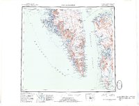
1952 Map of Port Alexander
USGS Topo · Published 1953About this map
Baranof Island and Kuiu Island define the intricate coastline of Southeast Alaska in this mid-century reconnaissance. The settlement at Port Alexander serves as a primary southern hub, complemented by smaller outposts like Port Armstrong and Toledo Harbor. This period reflects an era of coastal industry, with several Canneries marked along the inlets, such as those at Washington Bay. The topography is dominated by massive peaks including Mt Hagemeister and Mt Rudakof, while the western edge is buffered by the St Lazaria National Wildlife Refuge. Numerous freshwater bodies like Redoubt Lake and Lake Irina sit just inland from deep fjords such as Crawfish Inlet, illustrating the region's complex glacial geography. Navigational landmarks like the Light at Cape Decision remain critical for vessels transiting Chatham Strait and the open Pacific Ocean.
Find a feature on this map
115 named features on this map. Tap any name to fly to it.
Don’t see what you’re looking for? This feature index may not catch every label — zoom into the map to look around manually.
Map Details
Editions of this 1952 Port Alexander Map
4 editions found

Other maps of this area

1948 · Sitka A-5
USGS Topo · 1:63,360

1948 · Sitka A-3
USGS Topo · 1:63,360

1948 · Sitka A-2
USGS Topo · 1:63,360

1948 · Port Alexander C-1
USGS Topo · 1:63,360

1948 · Petersburg A-6
USGS Topo · 1:63,360

1948 · Port Alexander A-1
USGS Topo · 1:63,360

1948 · Petersburg B-6
USGS Topo · 1:63,360

1948 · Sumdum A-6
USGS Topo · 1:63,360

1948 · Port Alexander B-1
USGS Topo · 1:63,360

1948 · Petersburg D-6
USGS Topo · 1:63,360