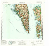
1952 Map of Port Alexander
USGS Topo · Published 1955About this map
Baronof Island and the rugged coastal geography of the Alexander Archipelago are captured during the post-war era of the early 1950s. This survey highlights the complex network of fjords and mountain peaks that defined the maritime economy of Southeast Alaska, featuring critical fishing and industrial outposts like Port Alexander and Port Armstrong. The interior of the island is dominated by high summits such as Mt Ada and Mt Rudakov, while numerous glacial lakes, including Benzeman Lake and Plotnikof Lake, feed the drainages leading to the Chatham Strait. Along the western edge, the St Lazaria National Wildlife Refuge marks the entrance to Sitka Sound, while the southern extremity terminates at the navigational landmarks of Cape Ommaney and the Lighthouse at Cape Decision.
Find a feature on this map
79 named features on this map. Tap any name to fly to it.
Don’t see what you’re looking for? This feature index may not catch every label — zoom into the map to look around manually.
Map Details
Editions of this 1952 Port Alexander Map
4 editions found

Other maps of this area

1948 · Sitka A-5
USGS Topo · 1:63,360

1948 · Sitka A-3
USGS Topo · 1:63,360

1948 · Sitka A-2
USGS Topo · 1:63,360

1948 · Port Alexander C-1
USGS Topo · 1:63,360

1948 · Petersburg A-6
USGS Topo · 1:63,360

1948 · Port Alexander A-1
USGS Topo · 1:63,360

1948 · Petersburg B-6
USGS Topo · 1:63,360

1948 · Sumdum A-6
USGS Topo · 1:63,360

1948 · Port Alexander B-1
USGS Topo · 1:63,360

1948 · Petersburg D-6
USGS Topo · 1:63,360