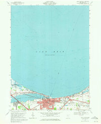
1969 Map of Port Clinton
USGS Topo · Published 1971About this map
Port Clinton serves as the hub of this Lake Erie shoreline study, situated where the Portage River meets the open water. The 1969 revision captures the town's mid-century footprint, showing the density of civic life from the Courthouse and City Hall to schools like Bataan Memorial Sch. To the west, the Ottawa National Wildlife Refuge marks a preserved coastal landscape, while to the east, the industrial character of Gypsum is evident through a prominent Quarry and Tailings piles.
Find a feature on this map
64 named features on this map. Tap any name to fly to it.
Don’t see what you’re looking for? This feature index may not catch every label — zoom into the map to look around manually.
Map Details
Editions of this 1969 Port Clinton Map
This is the sole edition of this map. No revisions or reprints were ever made.
Other maps of this area

1900 · Oak Harbor
USGS Topo · 1:62,500

1901 · Put-In-Bay
USGS Topo · 1:62,500

1901 · Bellevue
USGS Topo · 1:62,500

1901 · Fremont
USGS Topo · 1:62,500

1903 · Bellevue
USGS Topo · 1:62,500

1903 · Fremont
USGS Topo · 1:62,500

1903 · Put In Bay
USGS Topo · 1:62,500

1952 · Lacarne
USGS Topo · 1:24,000

1952 · Oak Harbor
USGS Topo · 1:62,500

1956 · Toledo
USGS Topo · 1:250,000