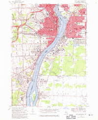
1968 Map of Port Huron
USGS Topo · Published 1971About this map
The St Clair River corridor defines this 1968 revision, capturing the industrial and international character of the border between Michigan and Ontario. In Port Huron, the density of civic life is evident through landmarks like the Post Office, Mercy Hospital, and Memorial Park, while the rail network is dominated by the Grand Trunk Western RR and the Port Huron and Detroit RR. Across the water, Sarnia and Point Edward show significant infrastructure, including an extensive Refinery, a Tank Farm, and several Sewage Disposal Ponds.
Find a feature on this map
83 named features on this map. Tap any name to fly to it.
Don’t see what you’re looking for? This feature index may not catch every label — zoom into the map to look around manually.
Map Details
Editions of this 1968 Port Huron Map
3 editions found
Other maps of this area

1912 · Port Huron
USGS Topo · 1:62,500

1928 · Hicky
USGS Topo · 1:62,500

1929 · Port Huron
USGS Topo · 1:62,500

1936 · St. Clair
USGS Topo · 1:31,680

1936 · Rattle Run
USGS Topo · 1:31,680

1939 · Port Huron
USGS Topo · 1:24,000

1939 · St. Clair
USGS Topo · 1:24,000

1939 · Smiths Creek
USGS Topo · 1:24,000

1942 · Rattle Run
USGS Topo · 1:24,000
1949 · Port Huron
USGS Topo · 1:24,000