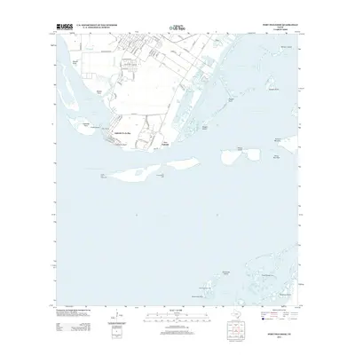
2013 Map of Port Ingleside
USGS Topo · Published 2013About this map
Corpus Christi Bay and the interconnected waters of Redfish Bay dominate this coastal landscape, illustrating the complex maritime geography of the Texas Gulf Coast. The settlement of Ingleside On-the-Bay sits along the northern shore, protected by the prominent McGloins Bluff and overlooking the deep-water access of the La Quinta Channel. The map details the intricate navigation systems required for these busy waters, including the Corpus Christi Channel and several aid-to-navigation landmarks like the Cut B East Range Light. To the south and east, the map transitions into the barrier island environments of Mustang Island and the bird-rich habitat of Shamrock Island. The presence of numerous named coves and cuts, such as Pink Shack Cove and Sinclair Cut, speaks to the long-standing importance of this area for local fishing, recreation, and commercial shipping.
Find a feature on this map
80 named features on this map. Tap any name to fly to it.
Don’t see what you’re looking for? This feature index may not catch every label — zoom into the map to look around manually.
Map Details
Editions of this 2013 Port Ingleside Map
This is the sole edition of this map. No revisions or reprints were ever made.
Other maps of this area

1925 · Aransas Pass
USGS Topo · 1:62,500

1925 · Oso Creek
USGS Topo · 1:62,500

1925 · Corpus Christi
USGS Topo · 1:62,500

1950 · Corpus Christi
USGS Topo · 1:250,000

1951 · Portland
USGS Topo · 1:24,000

1951 · Corpus Christi
USGS Topo · 1:62,500

1951 · Crane Islands NW
USGS Topo · 1:24,000

1951 · Oso Creek NE
USGS Topo · 1:24,000

1951 · Oso Creek
USGS Topo · 1:62,500

1951 · Crane Islands
USGS Topo · 1:62,500