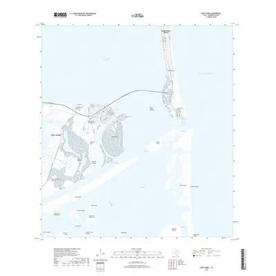
2019 Map of Port Isabel
USGS Topo · Published 2019About this map
Port Isabel stands as a central maritime hub at the southern tip of Texas, where the Brownsville Ship Channel and the Intracoastal Waterway intersect to shape the region's commercial character. The landscape is defined by a series of low-lying coastal elevations known as lomas, such as Loma del Islote and Loma de la Draga, which rise above the wetlands and tidal flats bordering South Bay. Across the water, the Queen Isabella Causeway serves as the vital artery connecting the mainland to the southern reaches of South Padre Island. This survey illustrates the intricate balance between modern infrastructure and the fragile geography of Brazos Island and Long Island, capturing the varied shoreline from the developed streets of the city to the pristine stretches of Boca Chica Beach and Del Mar Beach.
Find a feature on this map
64 named features on this map. Tap any name to fly to it.
Don’t see what you’re looking for? This feature index may not catch every label — zoom into the map to look around manually.
Map Details
Editions of this 2019 Port Isabel Map
This is the sole edition of this map. No revisions or reprints were ever made.
Other maps of this area

1929 · La Coma
USGS Topo · 1:24,000

1929 · Palmito Hill
USGS Topo · 1:24,000

1929 · Point Isabel
USGS Topo · 1:24,000

1929 · Laguna Vista
USGS Topo · 1:24,000

1930 · Padre Island No. 1
USGS Topo · 1:24,000

1934 · Port Isabel
USGS Topo · 1:31,680

1934 · La Coma
USGS Topo · 1:31,680

1935 · Padre Island No 1
USGS Topo · 1:31,680

1936 · Palmito Hill
USGS Topo · 1:31,680

1936 · Laguna Vista
USGS Topo · 1:31,680