
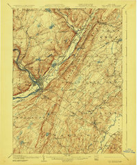
1908 Map of Port Jervis
USGS Topo · Published 1908About this map
Port Jervis serves as the focal point of this tri-state region, situated at the confluence where the Delaware River meets the Neversink River. The landscape is dominated by the linear ridges of Shawangunk Mountain and the Kittatinny Mountains, with the prominent High Point peak overlooking the valley. This era reveals a complex network of transportation, where the Erie RR and the Ontario and Western RR intersect near the river junction, supporting the local economy alongside remnants of earlier infrastructure like the Old Bolton Basin.
Find a feature on this map
93 named features on this map. Tap any name to fly to it.
Don’t see what you’re looking for? This feature index may not catch every label — zoom into the map to look around manually.
Map Details
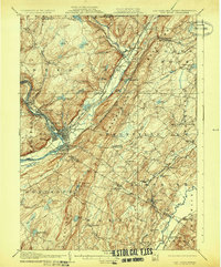
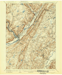
Editions of this 1908 Port Jervis Map
4 editions found
Other maps of this area

1888 · Franklin
USGS Topo · 1:62,500

1891 · Greenwood Lake
USGS Topo · 1:62,500

1891 · Wallpack
USGS Topo · 1:62,500

1893 · Greenwood Lake
USGS Topo · 1:62,500

1893 · Wallpack
USGS Topo · 1:62,500

1894 · Franklin
USGS Topo · 1:62,500

1897 · Franklin
USGS Topo · 1:62,500

1903 · Franklin Furnace
USGS Topo · 1:62,500

1903 · Greenwood Lake
USGS Topo · 1:62,500

1904 · Ellenville
USGS Topo · 1:62,500