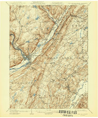
1908 Map of Port Jervis
USGS Topo · Published 1944About this map
Port Jervis serves as the focal point of this tri-state region, where the Delaware River forms the border between New York, New Jersey, and Pennsylvania. The town's significance as a transportation hub at the turn of the century is evident in the convergence of multiple rail lines, including the Erie RR and the Port Jervis and Montecello Line. The geography is defined by the sharp rise of Shawangunk Mountain and the Neversink River valley, which funnels early development into narrow corridors of commerce and industry.
Find a feature on this map
80 named features on this map. Tap any name to fly to it.
Don’t see what you’re looking for? This feature index may not catch every label — zoom into the map to look around manually.
Map Details
Editions of this 1908 Port Jervis Map
4 editions found

Other maps of this area

1888 · Franklin
USGS Topo · 1:62,500

1891 · Greenwood Lake
USGS Topo · 1:62,500

1891 · Wallpack
USGS Topo · 1:62,500

1893 · Greenwood Lake
USGS Topo · 1:62,500

1893 · Wallpack
USGS Topo · 1:62,500

1894 · Franklin
USGS Topo · 1:62,500

1897 · Franklin
USGS Topo · 1:62,500

1903 · Franklin Furnace
USGS Topo · 1:62,500

1903 · Greenwood Lake
USGS Topo · 1:62,500

1904 · Ellenville
USGS Topo · 1:62,500