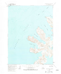
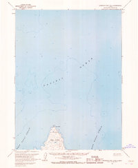
1963 Map of Port Moller A-1
USGS Topo · Published 1984About this map
Nagai Island dominates this maritime survey of the Shumagin Islands, characterized by its deeply recessed bays and prominent coastal landmarks. The eastern coastline is defined by several protected anchorages, including Sanborn Harbor, Eagle Harbor, and Falmouth Harbor, each separated by narrow, finger-like peninsulas terminating at points like Wooly Head and Cape Horn. To the northwest, across the deep waters of West Nagai Strait, lies the corner of Popof Island at Popof Head. This 1963 field-annotated data shows the island's intricate geography before modern changes, noting small maritime features like Larsen Bay and Caton Cove. The soundings and depth curves, compiled from hydrographic charts, provide a detailed profile of the surrounding Pacific Ocean floor as it relates to the steep elevations of the island terrain.
Find a feature on this map
17 named features on this map. Tap any name to fly to it.
Don’t see what you’re looking for? This feature index may not catch every label — zoom into the map to look around manually.
Map Details
Editions of this 1963 Port Moller A-1 Map
2 editions found
Other maps of this area

1951 · Stepovak Bay
USGS Topo · 1:250,000

1953 · Port Moller
USGS Topo · 1:250,000

1963 · Port Moller A-1
USGS Topo · 1:63,360

1963 · Port Moller A-2
USGS Topo · 1:63,360

1963 · Port Moller B-2
USGS Topo · 1:63,360

1963 · Port Moller B-1
USGS Topo · 1:63,360
1963 · Simeonof Island D-3
USGS Topo · 1:63,360
1963 · Stepovak Bay A-6
USGS Topo · 1:63,360
1963 · Simeonof Island D-4
USGS Topo · 1:63,360
1963 · Stepovak Bay B-6
USGS Topo · 1:63,360