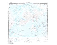
1953 Map of Port Moller
USGS Topo · Published 1973About this map
Settlement Point marks a rare site of human habitation on this maritime landscape where the Alaska Peninsula meets the Bering Sea. The 1950s era geography is defined by a deeply indented coastline and dramatic peaks, ranging from Apollo Mtn on the southern islands to the towering heights of Staniukovich Mtn further north. This survey illustrates the intricate network of tidal channels and lagoons, such as Nelson Lagoon and the narrow passage of Hague Channel, which provided essential navigation routes for local vessels.
Find a feature on this map
109 named features on this map. Tap any name to fly to it.
Don’t see what you’re looking for? This feature index may not catch every label — zoom into the map to look around manually.
Map Details
Editions of this 1953 Port Moller Map
3 editions found
Other maps of this area

1943 · Fort Randall
USGS Topo · 1:250,000

1949 · False Pass
USGS Topo · 1:250,000

1949 · Fort Randall
USGS Topo · 1:250,000

1950 · False Pass
USGS Topo · 1:250,000

1950 · Fort Randall
USGS Topo · 1:250,000

1951 · Stepovak Bay
USGS Topo · 1:250,000

1953 · Port Moller
USGS Topo · 1:250,000

1963 · Port Moller D-5
USGS Topo · 1:63,360

1963 · Port Moller A-5
USGS Topo · 1:63,360
1963 · Port Moller A-4
USGS Topo · 1:63,360