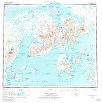
1953 Map of Port Moller
USGS Topo · Published 1974About this map
The coastal landscape of the Alaska Peninsula is defined here by the deep inlets of Port Moller and Herendeen Bay, where the maritime economy centered on salmon and natural resources is clearly visible. The Nelson Lagoon Cannery stands as a primary economic hub near the mouth of Nelson Lagoon, supported by a network of scattered Cabins and a designated Landing Area. This 1953 compilation, based on surveys dating back to the late 1920s, shows a region where water is the primary corridor for movement, connecting isolated outposts like Pavlof and Settlements Point. Evidence of early mineral exploration appears at Mine Hbt and several Drill Hole sites along the rugged coastline near Coal Bluff and Marble Pt. The terrain transitions from the volcanic heights of Pinnacle Peak and Staniukovich Mtn down to the extensive marshes and braided streams of the Caribou River and David River.
Find a feature on this map
203 named features on this map. Tap any name to fly to it.
Don’t see what you’re looking for? This feature index may not catch every label — zoom into the map to look around manually.
Map Details
Editions of this 1953 Port Moller Map
3 editions found
Other maps of this area

1943 · Fort Randall
USGS Topo · 1:250,000

1949 · False Pass
USGS Topo · 1:250,000

1949 · Fort Randall
USGS Topo · 1:250,000

1950 · False Pass
USGS Topo · 1:250,000

1950 · Fort Randall
USGS Topo · 1:250,000

1951 · Stepovak Bay
USGS Topo · 1:250,000

1953 · Port Moller
USGS Topo · 1:250,000

1963 · Port Moller D-5
USGS Topo · 1:63,360

1963 · Port Moller A-5
USGS Topo · 1:63,360
1963 · Port Moller A-4
USGS Topo · 1:63,360