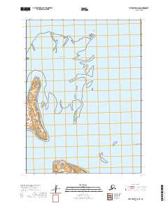
2020 Map of Port Moller D-3 NE
USGS Topo · Published 2020About this map
Port Moller and the surrounding coastal waters of Bristol Bay dominate this topographical survey of the Alaska Peninsula shoreline. The map documents a complex landscape of shifting sandbars, coastal wetlands, and tidal channels, most notably the Hague Channel that snakes through the eastern waters. Pointed landforms like Fawn Point and Doe Point define the rugged western coastline of this quadrangle, while Point Divide marks the southern entry into the bay systems. The absence of roads or permanent settlements in this 2020 record reflects the wilderness character of the Aleutians East region, where the primary landmarks are defined by the intersection of sea and tundra rather than human industry.
Find a feature on this map
12 named features on this map. Tap any name to fly to it.
Don’t see what you’re looking for? This feature index may not catch every label — zoom into the map to look around manually.
Map Details
Editions of this 2020 Port Moller D-3 NE Map
This is the sole edition of this map. No revisions or reprints were ever made.
Other maps of this area

1953 · Port Moller
USGS Topo · 1:250,000

1963 · Port Moller D-3
USGS Topo · 1:63,360

1963 · Port Moller D-2
USGS Topo · 1:63,360
1963 · Chignik A-8
USGS Topo · 1:63,360

1988 · Port Moller
USGS Topo · 1:250,000
2020 · Port Moller D-3 NW
USGS Topo · 1:25,000
2020 · Port Moller D-3 SE
USGS Topo · 1:25,000
2020 · Port Moller D-3 SW
USGS Topo · 1:25,000
2020 · Port Moller D-2 SW
USGS Topo · 1:25,000
2020 · Port Moller D-3 OE N SE
USGS Topo · 1:25,000