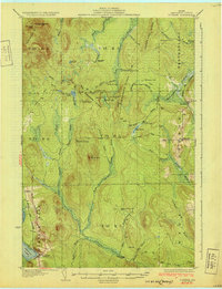
1931 Map of Portage
USGS Topo · Published 1931About this map
Portage and Buffalo serve as the primary rail hubs in this northern Maine landscape, situated along the Bangor and Aroostook railroad during the late 1920s. The map reveals an economy and social structure deeply tied to timber and wilderness management, evidenced by the numerous sporting and logging outposts such as Holmquist Camp, Carr Camp, and Sands Camp scattered throughout the unorganized townships.
Find a feature on this map
66 named features on this map. Tap any name to fly to it.
Don’t see what you’re looking for? This feature index may not catch every label — zoom into the map to look around manually.
Map Details
Editions of this 1931 Portage Map
3 editions found

Other maps of this area

1927 · Stockholm
USGS Topo · 1:48,000

1927 · Square Lake
USGS Topo · 1:48,000

1928 · Eagle Lake
USGS Topo · 1:48,000

1928 · Winterville
USGS Topo · 1:48,000

1929 · Portage
USGS Topo · 1:62,500

1929 · Caribou
USGS Topo · 1:48,000

1930 · Greenlaw
USGS Topo · 1:48,000

1931 · Square Lake
USGS Topo · 1:62,500

1931 · Ashland
USGS Topo · 1:48,000

1931 · Eagle Lake
USGS Topo · 1:62,500