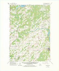
1963 Map of Porterfield
USGS Topo · Published 1982About this map
Peshtigo and the lower reaches of the Peshtigo River dominate this mid-century landscape, which is defined by a dense network of early rural education and industry. Small schoolhouses like Job Place Sch, Payne Sch, and Woulf Sch serve the farming communities of Grover and Porterfield, while the widespread presence of Gravel Pits and quarries speaks to the region's resource extraction. Transportation is dictated by the Chicago Milwaukee St Paul and Pacific and the Chicago and North Western rail lines, which intersect at strategic points like Bagley Junction. To the north, Lake Noquebay provides a significant water feature, while the Potato Rapids Dam manages the river's flow near the southeastern border. This survey preserves the locations of local landmarks such as the Peshtigo Lookout Tower and St Johns Ch, offering a clear view of Marinette County before modern consolidation changed the rural character.
Find a feature on this map
56 named features on this map. Tap any name to fly to it.
Don’t see what you’re looking for? This feature index may not catch every label — zoom into the map to look around manually.
Map Details
Editions of this 1963 Porterfield Map
2 editions found

Other maps of this area

1939 · Marinette
USGS Topo · 1:48,000

1939 · Porterfield
USGS Topo · 1:48,000

1940 · Athelstane
USGS Topo · 1:48,000

1941 · Coleman
USGS Topo · 1:48,000

1942 · Athelstane
USGS Topo · 1:48,000

1942 · Coleman
USGS Topo · 1:48,000

1942 · Porterfield
USGS Topo · 1:48,000

1942 · Wausaukee
USGS Topo · 1:48,000

1947 · Wausaukee
USGS Topo · 1:48,000

1949 · Stephenson
USGS Topo · 1:48,000