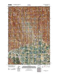
2011 Map of Porters Flat
USGS Topo · Published 2011About this map
The Snake River defines the western edge of this landscape on the Oregon-Idaho border, where the historic crossing at Porters Ferry once connected the high desert plains. This 2011 survey reveals an intricate network of water management essential to life in Malheur County, featuring the Galloway Canal, Smith-Hemenway Lateral, and Domby Ditch. These irrigation features support the agricultural settlements of Eaton, Jonathan, and the namesake Porters Flat. To the north, the terrain rises sharply toward Kelly Mountain and Haystack, contrasting with the level expanses of West Weiser Flat. Local transport is anchored by Olds Ferry Rd, following the river's course past Porters Island. The map documents a rural corridor where family-named roads like Pringle Rd and Ferrel Rd link isolated homesteads to the vital water sources of Scott Creek and Warm Springs Creek.
Find a feature on this map
38 named features on this map. Tap any name to fly to it.
Don’t see what you’re looking for? This feature index may not catch every label — zoom into the map to look around manually.
Map Details
Editions of this 2011 Porters Flat Map
This is the sole edition of this map. No revisions or reprints were ever made.
Other maps of this area

1897 · Weiser
USGS Topo · 1:125,000

1951 · Moores Hollow
USGS Topo · 1:24,000

1951 · Moores Hollow
USGS Topo · 1:62,500

1951 · Weiser South
USGS Topo · 1:24,000

1952 · Olds Ferry NW
USGS Topo · 1:24,000

1952 · Olds Ferry
USGS Topo · 1:24,000

1952 · Olds Ferry
USGS Topo · 1:62,500

1952 · Olds Ferry SE
USGS Topo · 1:24,000

1953 · Mann Creek
USGS Topo · 1:62,500

1955 · Baker
USGS Topo · 1:250,000