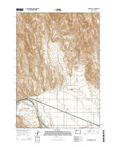
2014 Map of Porters Flat
USGS Topo · Published 2014About this map
The Snake River defines the border between Oregon and Idaho in this 2014 survey, winding past the agricultural flats of Malheur County. This riverfront landscape is dominated by a complex network of irrigation infrastructure essential for local farming, including the Galloway Canal, Domby Ditch, and Grimmet Lateral. Small rural settlements like Eaton and Jonathan are situated near the river, while West Weiser Flat and Porters Flat represent the developed floodplains that have historically supported the region's homesteads.
Find a feature on this map
48 named features on this map. Tap any name to fly to it.
Don’t see what you’re looking for? This feature index may not catch every label — zoom into the map to look around manually.
Map Details
Editions of this 2014 Porters Flat Map
This is the sole edition of this map. No revisions or reprints were ever made.
Other maps of this area

1897 · Weiser
USGS Topo · 1:125,000

1951 · Moores Hollow
USGS Topo · 1:24,000

1951 · Moores Hollow
USGS Topo · 1:62,500

1951 · Weiser South
USGS Topo · 1:24,000

1952 · Olds Ferry NW
USGS Topo · 1:24,000

1952 · Olds Ferry
USGS Topo · 1:24,000

1952 · Olds Ferry
USGS Topo · 1:62,500

1952 · Olds Ferry SE
USGS Topo · 1:24,000

1953 · Mann Creek
USGS Topo · 1:62,500

1955 · Baker
USGS Topo · 1:250,000