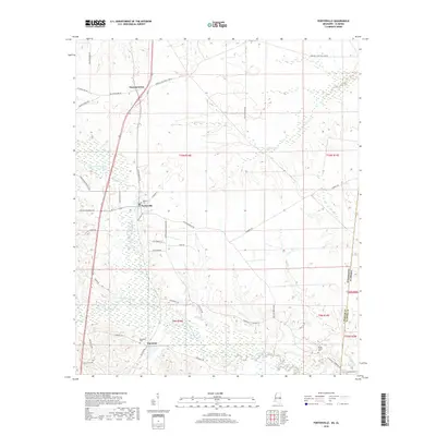
2018 Map of Porterville
USGS Topo · Published 2018About this map
Porterville sits near the heart of this landscape along the border of Mississippi and Alabama, representing a quiet agricultural and residential area in Kemper County. The terrain is defined by the winding course of the Sucarnoochee River and its various tributaries, including Quilby Cr and Pawticfaw Creek. Smaller settlements like Sucarnoochee to the north and Enondale to the south anchor the local road network, which includes numerous family-named routes such as Dan Whitsett Rd and Son Mobley Rd. For those tracing local heritage, the map identifies several significant burial sites, including Robbins Cem, Enondale Cem, and Briggs Chapel Cem. These landmarks, along with the distinct survey lines of t10n r18e and t9n r19e, illustrate the enduring land divisions and rural community structures of the early 21st century.
Find a feature on this map
41 named features on this map. Tap any name to fly to it.
Don’t see what you’re looking for? This feature index may not catch every label — zoom into the map to look around manually.
Map Details
Editions of this 2018 Porterville Map
This is the sole edition of this map. No revisions or reprints were ever made.
Other maps of this area

1953 · Meridian
USGS Topo · 1:250,000

1957 · Meridian
USGS Topo · 1:250,000

1962 · Lauderdale
USGS Topo · 1:24,000

1962 · Oak Grove
USGS Topo · 1:24,000

1963 · Townsend
USGS Topo · 1:24,000

1965 · Meridian
USGS Topo · 1:250,000

1973 · Scooba
USGS Topo · 1:24,000
1973 · Geiger
USGS Topo · 1:24,000

1974 · Boyd
USGS Topo · 1:24,000
1974 · Tamola
USGS Topo · 1:24,000