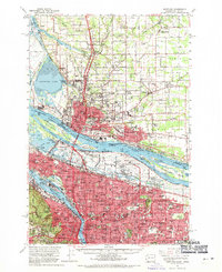
1961 Map of Portland
USGS Topo · Published 1970About this map
The Columbia River and Willamette River converge in this mid-century portrait of a growing Pacific Northwest corridor. The map details the dense neighborhoods of Portland, Oregon, and Vancouver, Washington, including the expansive footprint of the Portland International Airport and the Vancouver Barracks. This era captures the transition of the riverfront, where massive industrial operations like the Aluminum Plant sit alongside residential expansion in areas like McLoughlin Heights and Hazel Dell. A notable historical detail is the notation of the Vanport City (Site), marking the location of the community destroyed by the 1948 flood. The region's transport network is well-represented, from the Portland Union Station hub and multiple rail lines like the Union Pacific RR to the emergent Banfield Expressway, illustrating how the metropolitan area began to stitch together its suburban outskirts during the post-war boom.
Find a feature on this map
148 named features on this map. Tap any name to fly to it.
Don’t see what you’re looking for? This feature index may not catch every label — zoom into the map to look around manually.
Map Details
Editions of this 1961 Portland Map
3 editions found
Other maps of this area

1897 · Portland
USGS Topo · 1:62,500

1905 · Portland
USGS Topo · 1:62,500

1911 · Boring
USGS Topo · 1:48,000

1914 · Boring
USGS Topo · 1:62,500

1914 · Oregon City
USGS Topo · 1:62,500

1915 · Hillsboro
USGS Topo · 1:62,500

1916 · Tualatin
USGS Topo · 1:62,500

1916 · Estacada
USGS Topo · 1:125,000

1918 · Hillsboro
USGS Topo · 1:62,500

1918 · Troutdale
USGS Topo · 1:62,500