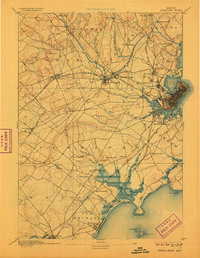
1893 Map of Portland
USGS Topo · Published 1906About this map
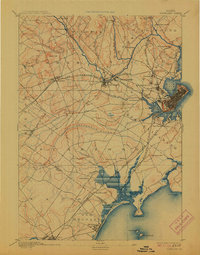
The Portland waterfront and its industrial suburbs are captured during a period of intense rail development in the late 19th century. Extensive rail networks including the Grand Trunk Railroad, Maine Central Railroad, and both divisions of the Boston and Maine Railroad converge on the city, illustrating its role as a regional transport hub. Beyond the urban core, the map details established village centers like Saccarappa and Cumberland Mills along the Presumpscot River, where the falls provided early power for manufacturing. Along the coast, the burgeoning resort character of the area is visible at Old Orchard and Pine Point. The landscape is a mix of tidal inlets like Back Cove and the Fore River, and inland drainage such as the winding Nonesuch River. Many smaller, localized place names like Ligonia and Knightsville reflect the distinct neighborhoods and rail depots that defined the late-Victorian Casco Bay region.
Find a feature on this map
72 named features on this map. Tap any name to fly to it.
Don’t see what you’re looking for? This feature index may not catch every label — zoom into the map to look around manually.
Map Details
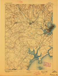
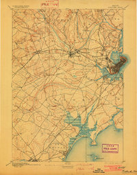
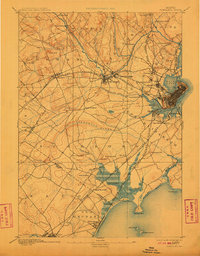
Editions of this 1893 Portland Map
6 editions found
Other maps of this area

1891 · Portland
USGS Topo · 1:62,500

1891 · Biddeford
USGS Topo · 1:62,500

1891 · Kennebunk
USGS Topo · 1:62,500

1891 · Buxton
USGS Topo · 1:62,500

1892 · Freeport
USGS Topo · 1:62,500

1892 · Buxton
USGS Topo · 1:62,500

1893 · Kennebunk
USGS Topo · 1:62,500

1893 · Biddeford
USGS Topo · 1:62,500

1893 · Portland
USGS Topo · 1:62,500

1893 · Casco Bay
USGS Topo · 1:62,500