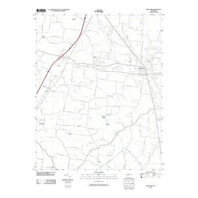
2010 Map of Portland
USGS Topo · Published 2010About this map
Portland serves as the primary hub in this portion of northern Sumner County, where the landscape transitions between developed residential corridors and agricultural valley lands. The area is defined by its numerous family and community burial grounds, including Cummings Cemetery, Hardin Cemetery, and Maple Hill Cemetery, which offer significant data points for genealogical research. Waterways like the Red River, Summers Branch, and Buntin Branch drain the terrain, which is further shaped by local landmarks such as Belcher Hollow and Phillip Bradshaw Lake. Transport infrastructure is prominent, featuring the intersection of major routes like Old US Hwy 31W and the presence of the Hodges Cherry Mound Airport. This 2010 survey illustrates the modern layout of rural roads such as Buntin Mill Rd and New Deal Potts Rd, reflecting decades of local land divisions and property boundaries.
Find a feature on this map
92 named features on this map. Tap any name to fly to it.
Don’t see what you’re looking for? This feature index may not catch every label — zoom into the map to look around manually.
Map Details
Editions of this 2010 Portland Map
This is the sole edition of this map. No revisions or reprints were ever made.
Other maps of this area

1903 · Nashville
USGS Topo · 1:125,000

1928 · Adolphus
USGS Topo · 1:48,000

1931 · Adolphus
USGS Topo · 1:62,500

1942 · Gallatin
USGS Topo · 1:100,000

1951 · Franklin
USGS Topo · 1:24,000

1951 · Prices Mill
USGS Topo · 1:24,000

1953 · Cottontown
USGS Topo · 1:24,000

1953 · Orlinda
USGS Topo · 1:24,000
1954 · White House
USGS Topo · 1:24,000
1954 · Hickory Flat
USGS Topo · 1:24,000