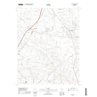
2019 Map of Portland
USGS Topo · Published 2019About this map
Portland and its surrounding rural communities in Sumner and Robertson counties are defined by a complex network of waterways and early burial grounds. The Red River and its tributaries, including Austin Br and Buntin Br, carve through the landscape, while small hamlets like Scattersville, Reubensville, and New Deal suggest a history of dispersed agricultural settlements. Genealogists will find a high density of family and community landmarks, such as Maple Hill Cem and Byrams Chapel, which anchor the heritage of this border region near the Kentucky line.
Find a feature on this map
167 named features on this map. Tap any name to fly to it.
Don’t see what you’re looking for? This feature index may not catch every label — zoom into the map to look around manually.
Map Details
Editions of this 2019 Portland Map
This is the sole edition of this map. No revisions or reprints were ever made.
Other maps of this area

1903 · Nashville
USGS Topo · 1:125,000

1928 · Adolphus
USGS Topo · 1:48,000

1931 · Adolphus
USGS Topo · 1:62,500

1942 · Gallatin
USGS Topo · 1:100,000

1951 · Franklin
USGS Topo · 1:24,000

1951 · Prices Mill
USGS Topo · 1:24,000

1953 · Cottontown
USGS Topo · 1:24,000

1953 · Orlinda
USGS Topo · 1:24,000
1954 · White House
USGS Topo · 1:24,000
1954 · Hickory Flat
USGS Topo · 1:24,000