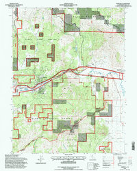
1994 Map of Portola
USGS Topo · Published 1998About this map
The Middle Fork Feather River carves through this mountain landscape, serving as the central corridor for the city of Portola and the nearby settlement of Delleker. This 1994 revision highlights a region defined by the complex boundary between the Plumas National Forest and the Tahoe National Forest, where high-elevation landmarks like Beckwourth Peak and Crocker Mountain overlook the broad expanse of the Sierra Valley to the east. The map records important local genealogy sites, including Shady Grove Cem, and social markers such as the High Sch and Whispering Pines. Notable infrastructure includes the Feather River Scenic Byway and various forest management features like the State Game Refuge 1-V and the Beckwourth area, providing a clear picture of land use in the northern Sierra Nevada during the late twentieth century.
Find a feature on this map
40 named features on this map. Tap any name to fly to it.
Don’t see what you’re looking for? This feature index may not catch every label — zoom into the map to look around manually.
Map Details
Editions of this 1994 Portola Map
This is the sole edition of this map. No revisions or reprints were ever made.
Other maps of this area

1890 · Sierraville
USGS Topo · 1:125,000

1891 · Downieville
USGS Topo · 1:125,000

1892 · Sierraville
USGS Topo · 1:125,000

1893 · Downieville
USGS Topo · 1:125,000

1894 · Sierraville
USGS Topo · 1:125,000

1895 · Downieville
USGS Topo · 1:125,000

1896 · Downieville
USGS Topo · 1:125,000

1897 · Downieville
USGS Topo · 1:125,000

1937 · Blairsden
USGS Topo · 1:48,000

1943 · Blairsden
USGS Topo · 1:62,500