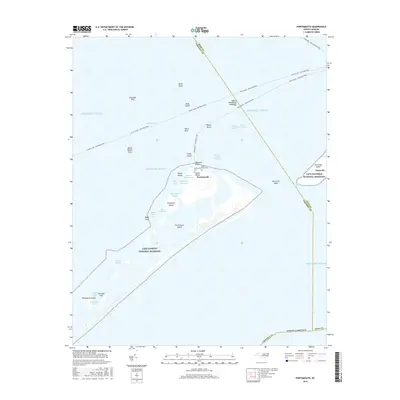
2016 Map of Portsmouth
USGS Topo · Published 2016About this map
Portsmouth Island and the Outer Banks coastline are preserved here within the Cape Lookout National Seashore and Cape Hatteras National Seashore. This barrier island landscape is defined by its maritime isolation, with the historic settlement of Portsmouth standing as a quiet landmark of coastal North Carolina history. The map detail highlights the tenuous connection between land and sea, documenting the small Community Cem and Babb-Dixon Cem which serve as reminders of the families who once lived among the dunes and tidal marshes.
Find a feature on this map
44 named features on this map. Tap any name to fly to it.
Don’t see what you’re looking for? This feature index may not catch every label — zoom into the map to look around manually.
Map Details
Editions of this 2016 Portsmouth Map
This is the sole edition of this map. No revisions or reprints were ever made.
Other maps of this area

1948 · Portsmouth
USGS Topo · 1:24,000
1948 · Ocracoke
USGS Topo · 1:24,000

1950 · Howard Reef
USGS Topo · 1:24,000

1950 · Portsmouth
USGS Topo · 1:24,000

1953 · Rocky Mount
USGS Topo · 1:250,000

1953 · Beaufort
USGS Topo · 1:250,000

1954 · Rocky Mount
USGS Topo · 1:250,000

1954 · Beaufort
USGS Topo · 1:250,000

1955 · Wanchese
USGS Topo · 1:250,000

1957 · Manteo
USGS Topo · 1:250,000