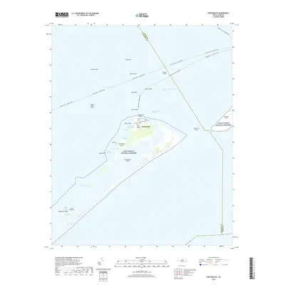
2019 Map of Portsmouth
USGS Topo · Published 2019About this map
Portsmouth sits at the northern terminus of the Cape Lookout National Seashore, separated from Ocracoke Island by the waters of the Ocracoke Inlet. This coastal landscape is defined by its maritime history, with numerous small graveyards including the Portsmouth Cem, Wallace Cem, and Babb-Dixon Cem marking the former village site. The map details the complex system of shoals and channels through the Outer Banks, such as Vera Cruz Shoal and Wallace Channel, which have long dictated the movement of vessels between the Pamlico Sound and the Atlantic. Ferry routes such as the Cedar Island - Ocracoke Ferry trace the deep-water paths past landmarks like Mount Vernon Rock and Shell Castle. The shifting geography of the barrier islands is evident in named landforms like Evergreen Island, Sheep Island, and the shoals of the High Hills Inlet.
Find a feature on this map
44 named features on this map. Tap any name to fly to it.
Don’t see what you’re looking for? This feature index may not catch every label — zoom into the map to look around manually.
Map Details
Editions of this 2019 Portsmouth Map
This is the sole edition of this map. No revisions or reprints were ever made.
Other maps of this area

1948 · Portsmouth
USGS Topo · 1:24,000
1948 · Ocracoke
USGS Topo · 1:24,000

1950 · Howard Reef
USGS Topo · 1:24,000

1950 · Portsmouth
USGS Topo · 1:24,000

1953 · Rocky Mount
USGS Topo · 1:250,000

1953 · Beaufort
USGS Topo · 1:250,000

1954 · Rocky Mount
USGS Topo · 1:250,000

1954 · Beaufort
USGS Topo · 1:250,000

1955 · Wanchese
USGS Topo · 1:250,000

1957 · Manteo
USGS Topo · 1:250,000