1950 Map of Portsmouth
USGS Topo · Published 1972About this map
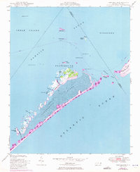
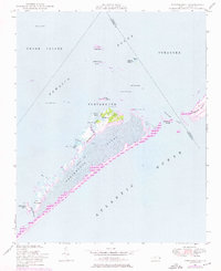
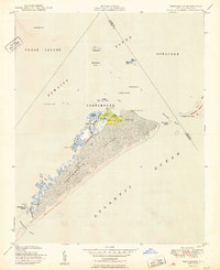
The maritime village of Portsmouth anchors this 1950 survey, which captures the complex island and inlet geography where Pamlico Sound meets the Atlantic Ocean. Situated on the northern tip of Portsmouth Island, the settlement is documented with specific landmarks including a Cupola and Spire, alongside the natural harbor formed by Casey Bay and the Baymarsh Thorofare. The map records a landscape in transition, with a ferry route crossing the sound and a telephone line stretching down the narrow barrier island.
Find a feature on this map
37 named features on this map. Tap any name to fly to it.
Don’t see what you’re looking for? This feature index may not catch every label — zoom into the map to look around manually.
Map Details
Editions of this 1950 Portsmouth Map
2 editions found
Other maps of this area
1948 · Portsmouth
USGS Topo · 1:24,000
1948 · Ocracoke
USGS Topo · 1:24,000
1950 · Howard Reef
USGS Topo · 1:24,000
1950 · Portsmouth
USGS Topo · 1:24,000

1953 · Rocky Mount
USGS Topo · 1:250,000

1953 · Beaufort
USGS Topo · 1:250,000

1954 · Rocky Mount
USGS Topo · 1:250,000

1954 · Beaufort
USGS Topo · 1:250,000
1955 · Wanchese
USGS Topo · 1:250,000
1957 · Manteo
USGS Topo · 1:250,000