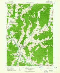
1961 Map of Portville
USGS Topo · Published 1963About this map
Portville stands at the confluence of the Oswayo River and the Allegheny River, serving as a central hub for the surrounding valley settlements in the early 1960s. The map illustrates a landscape defined by sharp elevation changes, where narrow hollows like Narvoo Hollow and Gleason Hollow lead away from the river plains into the high timber of Typnahda Mountain and the Ridge. Transportation is a key theme, with the Pennsylvania Railroad and the Pennsylvania Rd following the natural contours of the river valley.
Find a feature on this map
51 named features on this map. Tap any name to fly to it.
Don’t see what you’re looking for? This feature index may not catch every label — zoom into the map to look around manually.
Map Details
Editions of this 1961 Portville Map
Other maps of this area

1898 · Olean
USGS Topo · 1:62,500

1925 · Belmont
USGS Topo · 1:62,500

1933 · Smethport
USGS Topo · 1:62,500

1934 · Coudersport
USGS Topo · 1:48,000

1937 · Smethport
USGS Topo · 1:62,500

1938 · Coudersport
USGS Topo · 1:62,500

1938 · Olean
USGS Topo · 1:62,500

1939 · Belmont
USGS Topo · 1:62,500

1943 · Olean
USGS Topo · 1:62,500

1957 · Warren
USGS Topo · 1:250,000