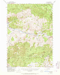
1951 Map of Post
USGS Topo · Published 1969About this map
The Crooked River snakes through the high desert landscape of central Oregon, serving as the central artery for the small settlement of Post. This early 1950s survey documents a rural community centered around the Post School and a Cemetery, where the river valley provided a corridor for travel and ranching. The landscape transitions from the riparian bottomlands to the timbered slopes of the Maury Mountains and the Ochoco National Forest. Resource extraction and land management are evident through features like the Maury Mtn Mines and the Tower Point Lookout. The map also captures the early recreational footprint of the region at Wiley Flat Camp Ground, while marking specific river miles, from Mile 97 to Mile 113, that delineate the remote stretch of water winding between Pollard Butte and Polk Butte.
Find a feature on this map
75 named features on this map. Tap any name to fly to it.
Don’t see what you’re looking for? This feature index may not catch every label — zoom into the map to look around manually.
Map Details
Editions of this 1951 Post Map
3 editions found
Other maps of this area

1946 · Eagle Rock
USGS Topo · 1:62,500

1948 · Eagle Rock
USGS Topo · 1:62,500

1948 · Ochoco Reservoir
USGS Topo · 1:62,500

1950 · Ochoco Reservoir
USGS Topo · 1:62,500

1951 · Post
USGS Topo · 1:62,500

1951 · Lookout Mtn
USGS Topo · 1:62,500

1955 · Crescent
USGS Topo · 1:250,000

1955 · Bend
USGS Topo · 1:250,000

1957 · Crescent
USGS Topo · 1:250,000

1957 · Bend
USGS Topo · 1:250,000