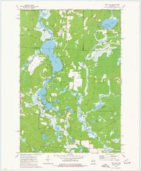
1973 Map of Post Lake
USGS Topo · Published 1977About this map
Post Lake sits at the heart of this Northwoods drainage system, where the Wolf River transitions through a series of expansive lakes and flowages. In the early 1970s, the landscape is defined by its complex hydrology, featuring the interconnected Upper Post Lake and Lower Post Lake, along with the wilder stretches of the Wolf River State Fishery Area. The mapping shows a region primarily shaped by water and timber, with residential development concentrated around the lake shores while the surrounding townships of Schoepke, Nashville, and Ainsworth remain heavily forested. Cultural markers like Knoke Spring and several gravel pits suggest the local natural resource economy of the era. The presence of smaller water bodies such as Miniwakan Lake, Aninnan Lake, and the Spider Creek Flowage illustrates the glacial character of the Langlade and Oneida County borderlands during this period of recreational growth.
Find a feature on this map
40 named features on this map. Tap any name to fly to it.
Don’t see what you’re looking for? This feature index may not catch every label — zoom into the map to look around manually.
Map Details
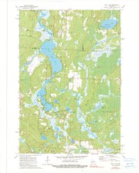
Editions of this 1973 Post Lake Map
2 editions found
Other maps of this area

1939 · Crandon
USGS Topo · 1:48,000

1940 · Monico
USGS Topo · 1:48,000

1941 · Crandon
USGS Topo · 1:48,000

1942 · Elcho
USGS Topo · 1:48,000

1942 · Pearson
USGS Topo · 1:48,000

1947 · Crandon
USGS Topo · 1:48,000

1950 · Monico
USGS Topo · 1:48,000

1950 · Elcho
USGS Topo · 1:48,000

1950 · Lily
USGS Topo · 1:48,000

1954 · Iron Mountain
USGS Topo · 1:250,000